
The Salford Trail
Explore the heritage, countryside and rural areas of Salford with a series of ten walks.
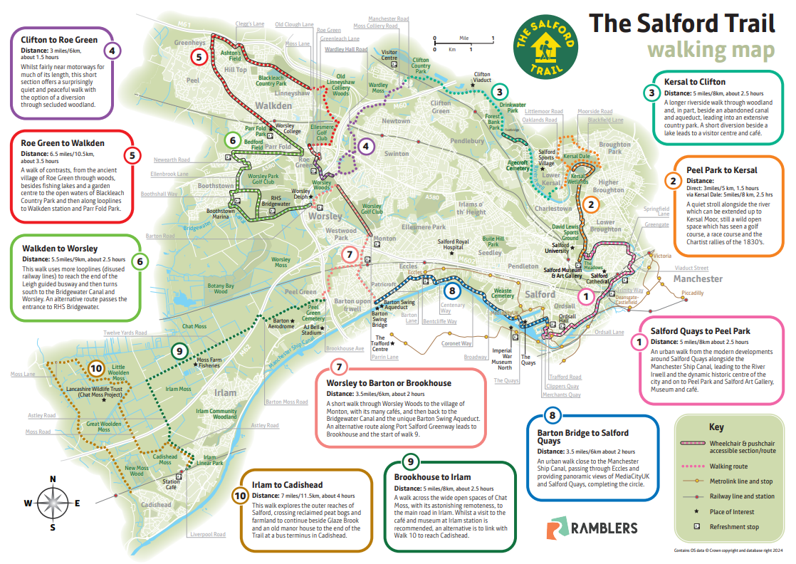
The Salford Trail is a long distance walk of about 50 miles / 80 kilometres entirely within the boundaries of the City of Salford.
The route is varied, going through rural areas and green spaces, with a little road walking in between.
Starting from the cityscape of Salford Quays, the Trail passes beside rivers and canals, through country parks, fields, woods and moss lands. It uses footpaths, tracks and disused railway lines known as ‘loop lines’. The Trail circles around to pass through Kersal, Agecroft, Walkden, Boothstown and Worsley before heading off to Chat Moss, Irlam and Cadishead.
It returns to Salford Quays passing the unique Barton swing aqueduct and Eccles. The Trail has been divided into ten sections, each accessible by public transport. Below are the links to the leaflets for each of the sections - and the most recently updated walk directions.
The Trail is waymarked throughout but waymarks can disappear! Also the route can change, sometimes at short notice, but the text only versions will be as up to date as possible.
The route leaflet has been completely updated here is the link.
Below are the most recently updated walk directions for each section:
1 Salford Quays to Peel Park . For the most recently updated walk directions click here.
2 Peel Park to Kersal. For the most recently updated walk directions click here.
3 Kersal to Clifton. For the most recently updated walk directions click here.
4 Clifton to Roe Green. For the most recently updated walk directions click here.
5 Roe Green to Walkden. For the most recently updated walk directions click here.
6 Walkden to Worsley . For the most recently updated walk directions click here.
7 Worsley to Barton or Brookhouse. For the most recently updated walk directions click here.
8 Barton Bridge to Salford Quays. For the most recently updated walk directions click here.
9 Brookhouse to Irlam . For the most recently updated walk directions click here.
10 Irlam to Cadishead. For the most recently updated walk directions click here.
If you have enjoyed The Salford Trail let us know, we would welcome your feedback.
Please report any missing waymarks, path defects, or problems with the route.
Click on the link below:
In conjuntion with Salford City Council and Transport for Greater Manchester.
| How it all began!
The current Salford Trail was developed by a whole team of Ramblers volunteers from the Manchester and Salford Group, but it was Roy Bullock who in 2007, noted that “certain towns around Salford had long distance trails” and, “Salford as a city having so much green space and such a rich history It deserved to be able to show these things to the full in the form of The Salford Trail.” He and Al Tomlinson, set out to create such a trail and by mid-2012 created a web site with the route and related information. This is still available and contains much of interest and can be accessed by following this link. The early days The original maps produced when the trail was established quickly became out of date and have been superseded by the latest version of the route map that is on the web site and the detailed walk directions for each section that are kept up to date. However, the original leaflets still have items of interest, and they can be accessed by following this link. |